40 Scary & Weird Things on Google Earth (With Coordinates, 2026)
Type a few numbers into Google Earth and you can be hovering over a burning crater in Turkmenistan, a ghost town filling with sand in Namibia, or a field of half-buried Cadillacs in Texas, all within a minute. That is why searches like “scary things on Google Earth coordinates” have exploded: it is free, it is real, and it is the closest thing to time travel your laptop can do.
The problem is that most lists online recycle the same blurry screenshots and coordinates that no longer land on anything. We checked every location below against published coordinates in November 2026. You get 40 scary, creepy, weird and funny places on Google Earth, a searchable coordinates finder with one-click links, a quick guide to entering coordinates and going back in time, and the truth behind a few viral Google Earth myths.

Quick answer: Some of the most popular weird and scary places on Google Earth are Area 51 in Nevada (37.2333, -115.8083), the abandoned city of Pripyat near Chernobyl (51.4061, 30.0572), Snake Island in Brazil (-24.4861, -46.6750), the Badlands Guardian face in Canada (50.0106, -110.1134), the Eye of the Sahara (21.1147, -11.3943) and the Darvaza “Door to Hell” crater (40.2525, 58.4396). To visit one, open Google Earth, paste the coordinates into the search box and press Enter.
Google Earth coordinates finder (all 40 places)
Filter by type, copy any coordinates, or roll a random place. Every link opens the exact spot in Google Earth or in Google Maps satellite view.
Google Earth coordinates finder
Filter the list, copy any coordinates, or hit random for a surprise. Opens in Google Earth or Google Maps satellite view.
| # | Place | Coordinates | Open |
|---|---|---|---|
| 1 | Area 51 Nevada, USA Scary | 37.2333, -115.8083 | Earth ↗ Maps ↗ |
| 2 | Pripyat Ukraine Scary | 51.4061, 30.0572 | Earth ↗ Maps ↗ |
| 3 | Snake Island (Ilha da Queimada Grande) Brazil Scary | -24.4861, -46.6750 | Earth ↗ Maps ↗ |
| 4 | Hashima Island Japan Scary | 32.6278, 129.7383 | Earth ↗ Maps ↗ |
| 5 | Centralia Pennsylvania, USA Scary | 40.8033, -76.3417 | Earth ↗ Maps ↗ |
| 6 | Poveglia Venice, Italy Scary | 45.3819, 12.3311 | Earth ↗ Maps ↗ |
| 7 | Lake Natron Tanzania Scary | -2.4167, 36.0000 | Earth ↗ Maps ↗ |
| 8 | Darvaza gas crater Turkmenistan Scary | 40.2525, 58.4396 | Earth ↗ Maps ↗ |
| 9 | Kolmanskop Namibia Scary | -26.7041, 15.2324 | Earth ↗ Maps ↗ |
| 10 | Six Flags New Orleans Louisiana, USA Scary | 30.0511, -89.9344 | Earth ↗ Maps ↗ |
| 11 | Island of the Dolls Mexico City, Mexico Scary | 19.2729, -99.0881 | Earth ↗ Maps ↗ |
| 12 | Teufelsberg Berlin, Germany Scary | 52.4975, 13.2411 | Earth ↗ Maps ↗ |
| 13 | Badlands Guardian Alberta, Canada Weird | 50.0106, -110.1134 | Earth ↗ Maps ↗ |
| 14 | Richat Structure (Eye of the Sahara) Mauritania Weird | 21.1147, -11.3943 | Earth ↗ Maps ↗ |
| 15 | Desert Breath Egypt Weird | 27.3804, 33.6322 | Earth ↗ Maps ↗ |
| 16 | Nazca Lines Peru Weird | -14.6975, -75.1350 | Earth ↗ Maps ↗ |
| 17 | The Boneyard Arizona, USA Weird | 32.1600, -110.8500 | Earth ↗ Maps ↗ |
| 18 | Spiral Jetty Utah, USA Weird | 41.4377, -112.6689 | Earth ↗ Maps ↗ |
| 19 | Bingham Canyon Mine Utah, USA Weird | 40.5230, -112.1510 | Earth ↗ Maps ↗ |
| 20 | Great Blue Hole Belize Weird | 17.3153, -87.5344 | Earth ↗ Maps ↗ |
| 21 | Dean's Blue Hole Bahamas Weird | 23.1064, -75.0086 | Earth ↗ Maps ↗ |
| 22 | Lake Hillier Western Australia Weird | -34.0958, 123.2028 | Earth ↗ Maps ↗ |
| 23 | Grand Prismatic Spring Wyoming, USA Weird | 44.5250, -110.8381 | Earth ↗ Maps ↗ |
| 24 | Palm Jumeirah Dubai, UAE Weird | 25.1181, 55.1333 | Earth ↗ Maps ↗ |
| 25 | Meteor Crater Arizona, USA Weird | 35.0281, -111.0233 | Earth ↗ Maps ↗ |
| 26 | North Sentinel Island Andaman Islands, India Remote | 11.5775, 92.2444 | Earth ↗ Maps ↗ |
| 27 | Point Nemo South Pacific Ocean Remote | -48.8767, -123.3933 | Earth ↗ Maps ↗ |
| 28 | Bouvet Island South Atlantic (Norway) Remote | -54.4200, 3.3600 | Earth ↗ Maps ↗ |
| 29 | Mount Roraima Venezuela, Brazil and Guyana Remote | 5.1433, -60.7625 | Earth ↗ Maps ↗ |
| 30 | Ryugyong Hotel Pyongyang, North Korea Remote | 39.0367, 125.7308 | Earth ↗ Maps ↗ |
| 31 | Lucy the Elephant Margate, New Jersey, USA Funny | 39.3206, -74.5119 | Earth ↗ Maps ↗ |
| 32 | The Big Duck Long Island, New York, USA Funny | 40.9072, -72.6224 | Earth ↗ Maps ↗ |
| 33 | The Basket Building Newark, Ohio, USA Funny | 40.0636, -82.3467 | Earth ↗ Maps ↗ |
| 34 | Dog Bark Park Inn Cottonwood, Idaho, USA Funny | 46.0575, -116.3445 | Earth ↗ Maps ↗ |
| 35 | Cadillac Ranch Amarillo, Texas, USA Funny | 35.1872, -101.9870 | Earth ↗ Maps ↗ |
| 36 | Carhenge Alliance, Nebraska, USA Funny | 42.1423, -102.8580 | Earth ↗ Maps ↗ |
| 37 | Prada Marfa Texas, USA Funny | 30.6035, -104.5185 | Earth ↗ Maps ↗ |
| 38 | Hole N" The Rock Moab, Utah, USA Funny | 38.3908, -109.4566 | Earth ↗ Maps ↗ |
| 39 | Hollywood Sign Los Angeles, California, USA Funny | 34.1341, -118.3216 | Earth ↗ Maps ↗ |
| 40 | Stonehenge Wiltshire, England Funny | 51.1789, -1.8261 | Earth ↗ Maps ↗ |
How to enter coordinates in Google Earth
Google Earth reads plain decimal coordinates: latitude first, then longitude, separated by a comma. Negative latitude means south of the equator, and negative longitude means west of Greenwich.
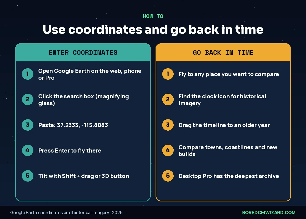
- Open Google Earth in your browser at earth.google.com, in the mobile app, or in Google Earth Pro on desktop.
- Click the search box (the magnifying glass).
- Paste the coordinates, for example 21.1147, -11.3943, and press Enter.
- Zoom and tilt: scroll to zoom and hold Shift while dragging (or tap the 3D button) to tilt the view.
Google Maps works too: paste the same coordinates into the search bar and switch the map layer to Satellite.
Scary Google Earth coordinates: creepy places (1–12)
These are the scary places on Google Earth that people come back to again and again: abandoned cities, forbidden islands and lakes that look like something out of a horror film. Every one is real, and several are places you legally cannot visit. If you want the scariest places on Google Earth first, start with Pripyat, Snake Island and the Darvaza crater; these creepy Google Earth coordinates are also the most shared scary coordinates on Google Earth online.
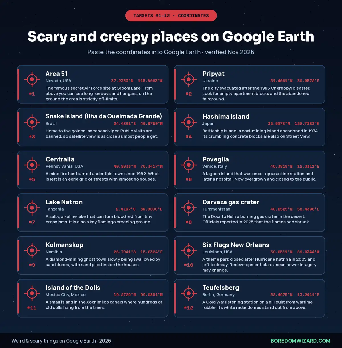
1. Area 51 (Nevada, USA): 37.2333, -115.8083. The famous secret Air Force site at Groom Lake. From above you can see long runways and hangars; on the ground the area is strictly off-limits.
2. Pripyat (Ukraine): 51.4061, 30.0572. The city evacuated after the 1986 Chernobyl disaster. Look for empty apartment blocks and the abandoned fairground.
3. Snake Island (Ilha da Queimada Grande) (Brazil): -24.4861, -46.6750. Home to the golden lancehead viper. Public visits are banned, so satellite view is as close as most people get.
4. Hashima Island (Japan): 32.6278, 129.7383. Battleship Island: a coal-mining island abandoned in 1974. Its crumbling concrete blocks are also on Street View.
5. Centralia (Pennsylvania, USA): 40.8033, -76.3417. A mine fire has burned under this town since 1962. What is left is an eerie grid of streets with almost no houses.
6. Poveglia (Venice, Italy): 45.3819, 12.3311. A lagoon island that was once a quarantine station and later a hospital. Now overgrown and closed to the public.
7. Lake Natron (Tanzania): -2.4167, 36.0000. A salty, alkaline lake that can turn blood red from tiny organisms. It is also a key flamingo breeding ground.
8. Darvaza gas crater (Turkmenistan): 40.2525, 58.4396. The Door to Hell: a burning gas crater in the desert. Officials reported in 2025 that the flames had shrunk.
9. Kolmanskop (Namibia): -26.7041, 15.2324. A diamond-mining ghost town slowly being swallowed by sand dunes, with sand piled inside the houses.
10. Six Flags New Orleans (Louisiana, USA): 30.0511, -89.9344. A theme park closed after Hurricane Katrina in 2005 and left to decay. Redevelopment plans mean newer imagery may change.
11. Island of the Dolls (Mexico City, Mexico): 19.2729, -99.0881. A small island in the Xochimilco canals where hundreds of old dolls hang from the trees.
12. Teufelsberg (Berlin, Germany): 52.4975, 13.2411. A Cold War listening station on a hill built from wartime rubble. Its white radar domes stand out from above.
Want more creepy inspiration? Turn your favorite into a sketch with our scary things to draw.
Weird things on Google Earth (13–25)
The weirdest things on Google Earth, and the weird places on Google Earth people screenshot most, are often natural or artistic: shapes that look designed, colors that look edited, and scales that are hard to believe until you switch to 3D. Paste these weird coordinates on Google Earth one after another for a quick world tour.
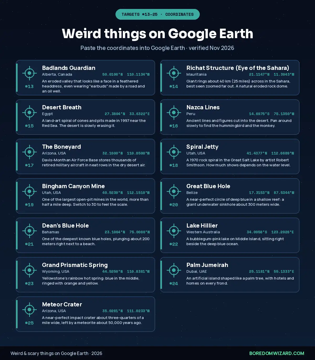
13. Badlands Guardian (Alberta, Canada): 50.0106, -110.1134. An eroded valley that looks like a face in a feathered headdress, even wearing “earbuds” made by a road and an oil well.
14. Richat Structure (Eye of the Sahara) (Mauritania): 21.1147, -11.3943. Giant rings about 40 km (25 miles) across in the Sahara, best seen zoomed far out. A natural eroded rock dome.
15. Desert Breath (Egypt): 27.3804, 33.6322. A land-art spiral of cones and pits made in 1997 near the Red Sea. The desert is slowly erasing it.
16. Nazca Lines (Peru): -14.6975, -75.1350. Ancient lines and figures cut into the desert. Pan around slowly to find the hummingbird and the monkey.
17. The Boneyard (Arizona, USA): 32.1600, -110.8500. Davis-Monthan Air Force Base stores thousands of retired military aircraft in neat rows in the dry desert air.
18. Spiral Jetty (Utah, USA): 41.4377, -112.6689. A 1970 rock spiral in the Great Salt Lake by artist Robert Smithson. How much shows depends on the water level.
19. Bingham Canyon Mine (Utah, USA): 40.5230, -112.1510. One of the largest open-pit mines in the world, more than half a mile deep. Switch to 3D to feel the scale.
20. Great Blue Hole (Belize): 17.3153, -87.5344. A near-perfect circle of deep blue in a shallow reef: a giant underwater sinkhole about 300 meters wide.
21. Dean’s Blue Hole (Bahamas): 23.1064, -75.0086. One of the deepest known blue holes, plunging about 200 meters right next to a beach.
22. Lake Hillier (Western Australia): -34.0958, 123.2028. A bubblegum-pink lake on Middle Island, sitting right beside the deep blue ocean.
23. Grand Prismatic Spring (Wyoming, USA): 44.5250, -110.8381. Yellowstone’s rainbow hot spring: blue in the middle, ringed with orange and yellow.
24. Palm Jumeirah (Dubai, UAE): 25.1181, 55.1333. An artificial island shaped like a palm tree, with hotels and homes on every frond.
25. Meteor Crater (Arizona, USA): 35.0281, -111.0233. A near-perfect impact crater about three-quarters of a mile wide, left by a meteorite about 50,000 years ago.
Mysterious and remote places (26–30)
Some places are creepy because of what you cannot see. These are among the most isolated, unreachable or unexplained spots you can fly to, and some of the creepiest places on Google Earth precisely because nothing seems to be there. They are also simply cool places on Google Earth to explore, and among the most creepy things on Google Earth to stumble on at night.
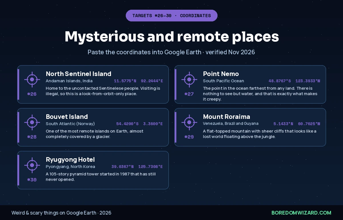
26. North Sentinel Island (Andaman Islands, India): 11.5775, 92.2444. Home to the uncontacted Sentinelese people. Visiting is illegal, so this is a look-from-orbit-only place.
27. Point Nemo (South Pacific Ocean): -48.8767, -123.3933. The point in the ocean farthest from any land. There is nothing to see but water, and that is exactly what makes it creepy.
28. Bouvet Island (South Atlantic (Norway)): -54.4200, 3.3600. One of the most remote islands on Earth, almost completely covered by a glacier.
29. Mount Roraima (Venezuela, Brazil and Guyana): 5.1433, -60.7625. A flat-topped mountain with sheer cliffs that looks like a lost world floating above the jungle.
30. Ryugyong Hotel (Pyongyang, North Korea): 39.0367, 125.7308. A 105-story pyramid tower started in 1987 that has still never opened.
Funny places on Google Earth (31–40)
Not everything has to be scary. These funny places on Google Earth are mostly American roadside giants, and they look even sillier from above. Save these funny Google Earth coordinates for when you need a laugh after the scary list; they are the funny things on Google Earth kids love too. Several have Street View, so drop down to the road for a closer look.
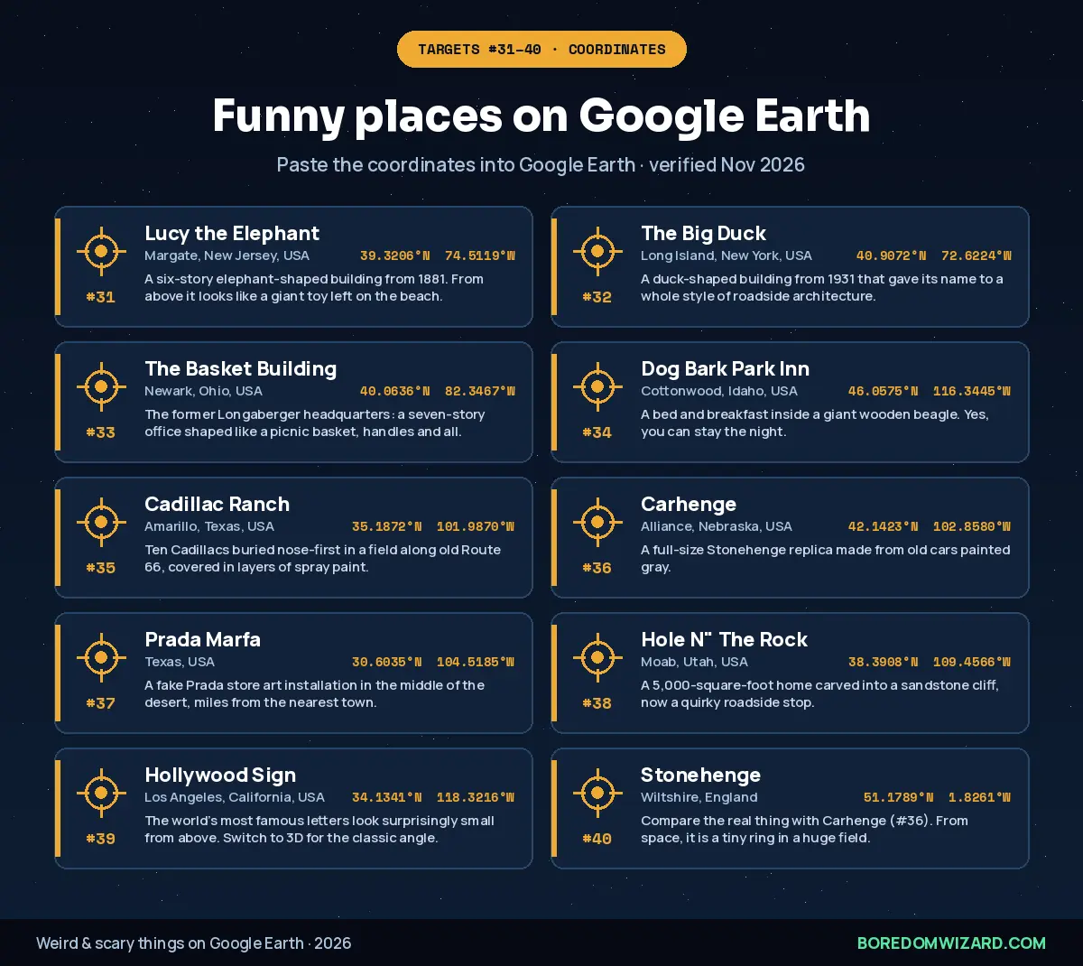
31. Lucy the Elephant (Margate, New Jersey, USA): 39.3206, -74.5119. A six-story elephant-shaped building from 1881. From above it looks like a giant toy left on the beach.
32. The Big Duck (Long Island, New York, USA): 40.9072, -72.6224. A duck-shaped building from 1931 that gave its name to a whole style of roadside architecture.
33. The Basket Building (Newark, Ohio, USA): 40.0636, -82.3467. The former Longaberger headquarters: a seven-story office shaped like a picnic basket, handles and all.
34. Dog Bark Park Inn (Cottonwood, Idaho, USA): 46.0575, -116.3445. A bed and breakfast inside a giant wooden beagle. Yes, you can stay the night.
35. Cadillac Ranch (Amarillo, Texas, USA): 35.1872, -101.9870. Ten Cadillacs buried nose-first in a field along old Route 66, covered in layers of spray paint.
36. Carhenge (Alliance, Nebraska, USA): 42.1423, -102.8580. A full-size Stonehenge replica made from old cars painted gray.
37. Prada Marfa (Texas, USA): 30.6035, -104.5185. A fake Prada store art installation in the middle of the desert, miles from the nearest town.
38. Hole N” The Rock (Moab, Utah, USA): 38.3908, -109.4566. A 5,000-square-foot home carved into a sandstone cliff, now a quirky roadside stop.
39. Hollywood Sign (Los Angeles, California, USA): 34.1341, -118.3216. The world’s most famous letters look surprisingly small from above. Switch to 3D for the classic angle.
40. Stonehenge (Wiltshire, England): 51.1789, -1.8261. Compare the real thing with Carhenge (#36). From space, it is a tiny ring in a huge field.
For more world-famous sights to explore, see our guide to famous landmarks.
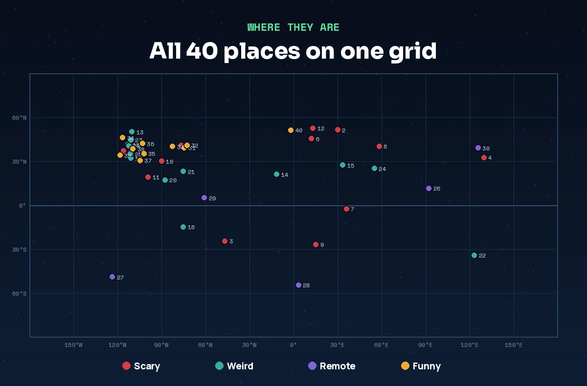
Where all 40 places are
| Type | How many | Best one to start with | Coordinates |
|---|---|---|---|
| Scary | 12 | Pripyat | 51.4061, 30.0572 |
| Weird | 13 | Eye of the Sahara | 21.1147, -11.3943 |
| Remote | 5 | Point Nemo | -48.8767, -123.3933 |
| Funny | 10 | Cadillac Ranch | 35.1872, -101.9870 |
How to go back in time on Google Earth
Historical imagery lets you see how a place looked years ago, and it makes many of these locations even creepier. Watch Kolmanskop sink into the sand, Lake Natron change color, or Spiral Jetty appear and disappear with the water level.
- Fly to the place using the coordinates above.
- Turn on historical imagery: look for the clock icon in Google Earth on the web or mobile, or in the toolbar of Google Earth Pro on desktop.
- Drag the timeline to an earlier year and compare.
- Use Google Earth Pro for the deepest archive; on desktop you can often go back decades in big cities.
Google Earth also hides a few playful features, like a flight simulator in Google Earth Pro. Find them in our Google easter eggs guide and our Google tricks list.
Google Earth myths: what is real and what is not
Viral Google Earth “discoveries” spread fast on TikTok and Reddit. Here is how to judge the big ones.
- Backrooms Google Earth coordinates: the Backrooms is an internet creepypasta, not a real place. Coordinates shared online usually point to ordinary empty offices or random fields.
- Sea monsters and “leviathan” sightings: giant shapes in the ocean are almost always boat wakes, reefs, image stitching seams or compression artifacts.
- Blurred buildings: some sensitive sites are blurred or shown at lower resolution, and some homeowners request blurring on Street View. A blur is not proof of a secret.
- “Live” satellite view: Google Earth is not live. Imagery is stitched from photos taken at different times, sometimes years apart.
- Hidden UFO bases: the famous ones, like Area 51, are real military sites, but nothing in the public imagery shows anything beyond runways, hangars and desert.
Use latitude and longitude coordinates to fly straight to any place in Google Earth.
Total Time: 2 minutes
Copy the coordinates
Copy decimal coordinates such as 37.2333, -115.8083 (latitude first, then longitude).
Open Google Earth
Open earth.google.com in your browser, the Google Earth app, or Google Earth Pro on desktop.
Paste into search
Click the search box, paste the coordinates and press Enter.
Zoom and tilt
Scroll to zoom and use Shift and drag, or the 3D button, to tilt for a better view.
Check older imagery
Open historical imagery and drag the timeline to see how the place has changed.
Natty’s take: Start with the Eye of the Sahara zoomed all the way out, then fly to Kolmanskop and turn on historical imagery. Seeing sand slowly fill a town year by year is creepier than any jump scare. Then end on Lucy the Elephant so you can sleep tonight.
Coordinates are rounded to four decimal places from published sources such as Wikipedia and checked in November 2026. Imagery changes over time, so if a spot looks different, try historical imagery.
Still exploring? Try our weird websites, websites to cure boredom and things to do when bored on the computer.
Weird and scary things on Google Earth FAQ
What are some scary things on Google Earth with coordinates?
Scary places on Google Earth include Pripyat near Chernobyl (51.4061, 30.0572), Snake Island in Brazil (-24.4861, -46.6750), Hashima Island in Japan (32.6278, 129.7383), Centralia in Pennsylvania (40.8033, -76.3417), Poveglia in Italy (45.3819, 12.3311) and the Darvaza gas crater in Turkmenistan (40.2525, 58.4396).
What is the creepiest place on Google Earth?
Popular picks for the creepiest place on Google Earth are Pripyat, the city abandoned after the Chernobyl disaster, and North Sentinel Island, home to an uncontacted tribe. Point Nemo, the place in the ocean farthest from any land, is creepy in a quieter way.
How do I enter coordinates in Google Earth?
Open Google Earth, click the search box, paste decimal coordinates with latitude first and longitude second, such as 37.2333, -115.8083, and press Enter. Google Earth flies straight to that point.
What are weird things on Google Earth?
Weird things on Google Earth include the Badlands Guardian face in Canada, the Eye of the Sahara in Mauritania, the Desert Breath spiral in Egypt, the Nazca Lines in Peru, the aircraft boneyard in Arizona and the pink Lake Hillier in Australia.
What are funny places on Google Earth?
Funny places on Google Earth include Lucy the Elephant in New Jersey, the Big Duck in New York, the basket-shaped Longaberger building in Ohio, the beagle-shaped Dog Bark Park Inn in Idaho, Cadillac Ranch in Texas and Carhenge in Nebraska.
How do you go back in time on Google Earth?
Fly to a place, then open historical imagery with the clock icon in Google Earth on the web or mobile, or in the Google Earth Pro toolbar on desktop, and drag the timeline to an earlier year.
Are there real Backrooms coordinates on Google Earth?
No. The Backrooms is an internet creepypasta, not a real place. Coordinates shared online usually point to ordinary offices, warehouses or empty fields.
Is Google Earth live?
No. Google Earth uses satellite and aerial images taken at different times, often months or years apart, so it does not show live events.
Updated November 2026. Coordinates checked against published sources; satellite imagery is updated over time and some places may look different.